![]() |
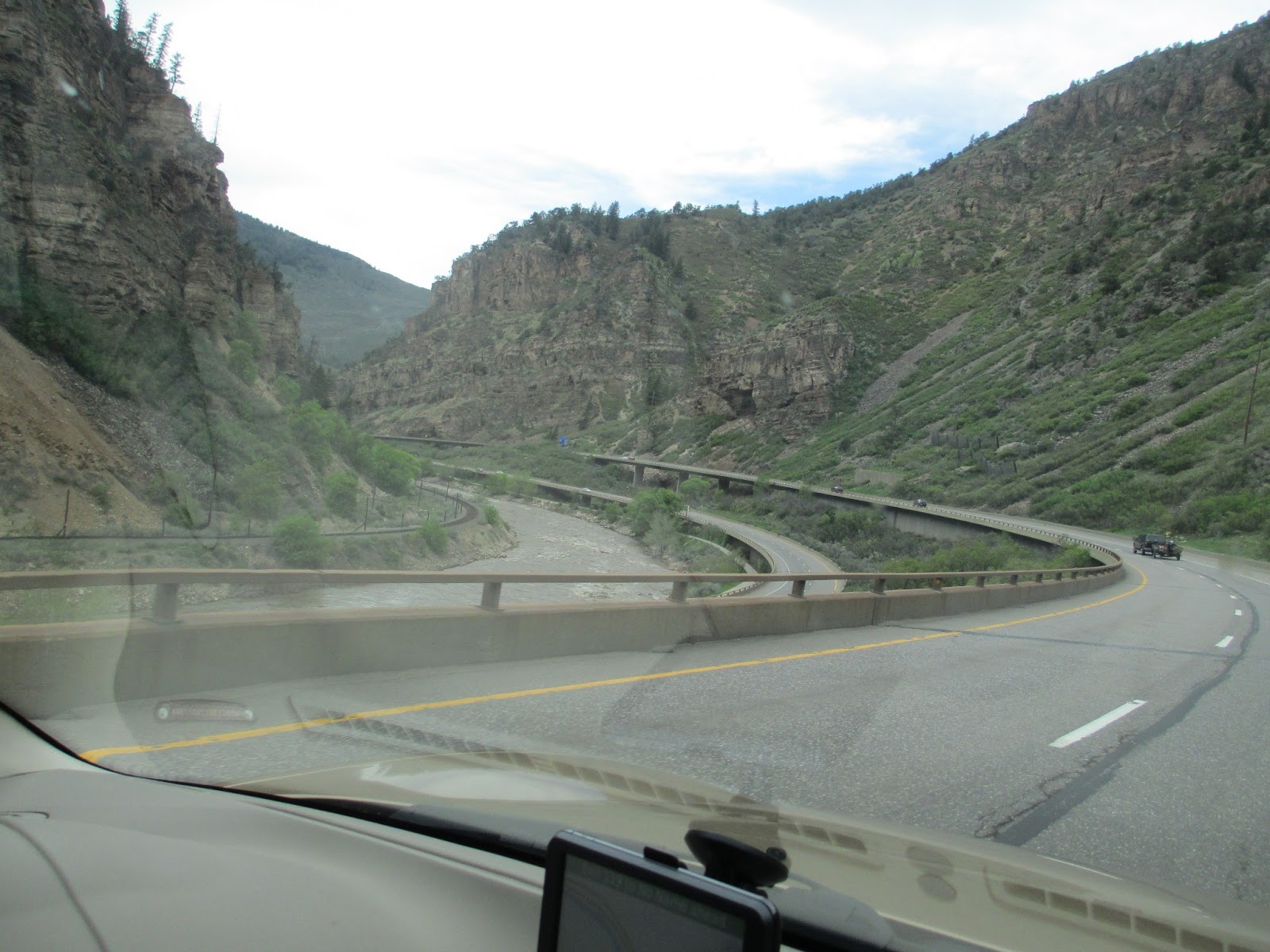
| image source The separate traffic lanes in no way interfere with the view or traffic flow. Rock formation and landforms were preserved or restored during construction. Blasted rock faces were stained to match the natural exposures. |
Thursday, July 18, 2013
Random Roadtrip ~ Glenwood Canyon
Our trip to Glenwood Springs was filled with beautiful scenery.
We took Interstate 70 from Denver and headed west. Even though it was mid-May and the trees and lawns were green in Denver, there was still quite a bit of snow in the Vail Pass area. And the trees there hadn't even begun to think about leaves.
As we began to drop down out of the Vail Valley, the vegetation became greener and red sandstone became more prominent in the hillsides.
A landscape very striking with its own sort of beauty.
The further west we traveled the hillsides became more barren and less colorful. The trees were replaced with sagebrush.
It is in this area that Gypsum is mined for sheetrock. It is also here that the Colorado River comes down from the north to join with the Eagle River and become the mighty force which carves out spectacular canyons.
But the 'moonscape' didn't last for long - we could see Glenwood Canyon in the distance.
Glenwood Canyon is a marvel of nature as well as a marvel of modern engineering. The Colorado River carved this gorge over the course of a multitude of eons.
The four-lane interstate which runs through Glenwood Canyon took an almost equally long length of time to complete. Begun in 1975 it wasn't completed until 1992. It was the last segment of the US Interstate road system to be finished.
The biggest challenge the Colorado Dept. of Transportation faced was how to put a four lane freeway into a canyon that was barely wide enough for a two-lane highway with minimal impact on the environment.
The solution was to construct two roadways, one nearly on top of the other - an elevated roadway which includes 40 bridges and viaducts spanning more than six miles between sections. The freeway also houses a state-of-the-art traffic management system which can warn travelers of weather or road conditions or road hazards. Along with a fleet of tow trucks and emergency vehicles available 24/7.
It took over 22 years and $500 million for the planning and execution of this roadway. And still, 21 years later, this section of I-70 is one of the nicest I have been on - and I have traveled some Interstate miles! It melds with the surroundings perfectly!
Rest area buildings are all earth sheltered so they blend in to the environment and to lower energy consumption. And composting toilets require no water.
A person would have no idea a building was even there until they were right in front of it.
The Interstate follows the contour of the canyon walls on one side and on the other side of the Colorado River are the railroad tracks for the Amtrak passenger train which runs from Denver to Glenwood Springs. (Sounds like Fun!) A bike path also runs the length of the canyon.
To read more about the Glenwood Canyon roadway, Click Here! Or Click Here!
Next week - REST STOP!
Tuesday, July 16, 2013
Bucket List
Most people these days have a 'Bucket List'. But not many folks have a 'List' that consists of 'Natural Disasters'.
It seems that one of my 'Lists' is just that! I've experienced: Blizzards, Dust Storm, Hurricane, Tornado (twice), Forest Fires, Earthquakes, Volcanic Eruption, Flooding (from Tropical Storm), and Drought (several times). I didn't choose to have such a 'List' but it appears that I am destined to have one - a 'Bucket List' of Natural Disasters. The latest additions to the 'List' are Mudslides and Flash Floods.
Two weeks ago we headed to Colorado Springs to get Hubby settled in at his new 'home' - an rv campground located in the foothills of Pikes Peak. Hubby had taken a new job in Colorado Springs and the rv was going to be his home for a bit.
Sometimes things happen for a reason. We didn't know the reason a wire had come loose from the engine causing the rv to break down as we were leaving Denver. We thought it was just a bit of aggravation. It was a quick repair but the delay saved us from a lot of headaches down the road. Headaches we wouldn't know about for another two hours.
A heavy rain shower took place in the foothills of Pikes Peak just as we were approaching Colorado Springs. This thunderstorm delivered a lot of rain in a very short amount of time over the burn scar from the Waldo Canyon fire which runs along Highway 24 out of Colo. Springs. Highway 24 runs along the bottom of the canyon which was formed by Fountain Creek. The Waldo Canyon fire took place in 2012 and devastated over 18, 245 acres.
![]() |
| Waldo Canyon Fire map |
Because of the fire, there is no vegetation to hold the soil in a heavy rain. And the cloudburst which occurred while we were driving on the Interstate, caused a massive amount of mud and rocks to come down the hillsides and cover not only the road and strand many motorists but also caused damage to numerous homes and turned Fountain Creek into a black, muddy mess of churning flood waters.
I had received an alert (Thanks to Nixle!) about the road closure. We managed to pull off the road (traffic was awful!) at a trailhead and park the rv. We decided to head into Manitou Springs for supper while we waited for the road to be cleared. We stopped at a Mexican place Hubby had heard good things about. But the restaurant was located on Fountain Creek and two large firetrucks were parked in their parking lot. As we approached the building, we overheard a fireman tell the manager that they needed to sandbag their deck by the creek in preparation for the next storm which was looming over the foothills. We decided to eat somewhere else.
About an hour and a half later the road was re-opened. The trip up the canyon was interesting - the road was slick with mud residue and there were huge piles of mud and rock along the sides of the road. But at least we hadn't been caught in any of it. The Universe was looking out for us.
A week later (just a week ago), another heavy rain occurred in the same area. This time video footage was taken of the mudslide and flash flood, which were even worse than the ones from the week before. I heard on the news that it takes from 3-5 years for an area to stabilize after it has been ravaged by fire.
The first two videos (below) were taken on Highway 24 last week during the mud-flood. The last video was taken along Fountain Creek by someone walking his dog. Pay close attention at the beginning of the video and you will see the color of the water darken as the muddy water from up the canyon enters the creek. And the siren you hear later in the last video, is a Flash Flood siren. These sirens can be found in many of the steep, narrow canyons which dot the foothills of the Front Range of the Colorado Rockies. That ear piercing sound warns hikers and residents of impending floods.
And then there was the tornado on Pikes Peak this past Saturday....
![]() |
| image source |
Labels:
colorado,
Earth,
HAARP,
natural disasters,
rocky mountains,
tornado
Sunday, July 14, 2013
Subscribe to:
Posts (Atom)


.jpg)