Wednesday, September 30, 2015

Misc. Pikes Peak Photos

Santa's Workshop - This is a major source of revenue for Santa Claus. He has to fund that workshop he has at the North Pole somehow! I do believe a Santa clone is running this place while the real Santa takes the Summer off.

image source

While sitting in the snack bar eating our donuts, we were amazed at the quantity of gnats that were everywhere. A person couldn't walk outside without breathing in a few or having them fly into your mouth.
Gnats on window at snack bar - yes, they are on the inside of the window
Kinda hard to see, but the roof of the trusty roadtrip car was covered with gnasty gnats!
Ravens were a common sight on both the drive up and back. Pairs of them could be seen cavorting in the air around the Summit House. I imagine they were feasting on the gnats!


Glen Cove Inn - Back in the Day, there was a ski area located here, which consisted of two runs. It is now just a gift shop and picnic place. There is a checkpoint located here for the vehicles traveling downhill/ A Ranger will check the temperature of the vehicle's brake pads. If the temperature is over 300deg, then the car must be parked until the brake pads cool off. The road up Pikes Peak is uphill to the top and downhill to the bottom. Driving in low gears is a must!


Checkpoint for brake temperature
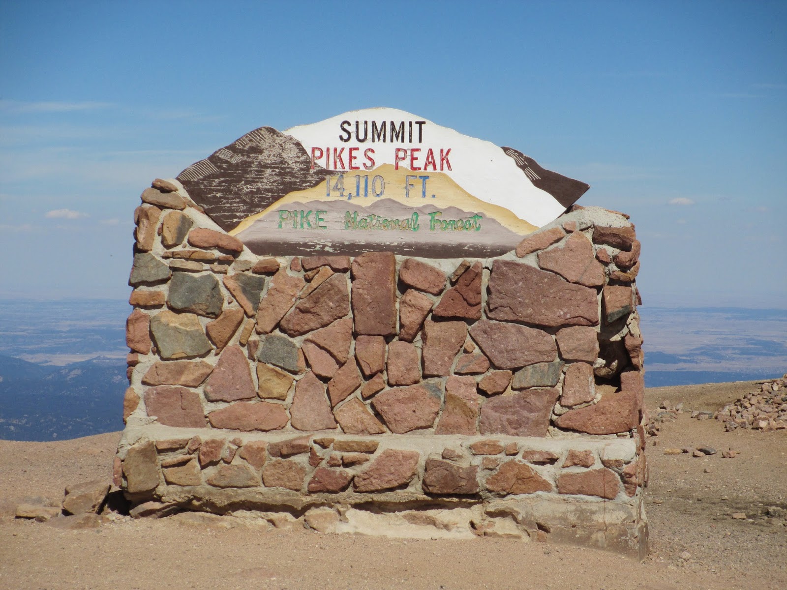
Not too far from the Summit is a place called the Devil's Playground. It is so named because of the way lightning jumps from rock to rock during a thunderstorm. There is no cover on the mountain at this elevation. Not a place a person would want to be in a thunderstorm!


It was interesting how the rocks along the ridges would stick up. They looked like the spines or plates along the back of dinosaurs. 


This is the burial marker of Carl Lotave. His ashes have been interred below the marker. Carl Lotave was a Swedish born painter who moved to Colorado Springs in 1899 to paint Native Americans for the Smithsonian. His burial place is in the granite boulder field to the southwest of the Summit House.


Another interesting marker is located waaayyyyyy out on a rock ledge to the west of the Summit House. It is a Masonic (?) plaque/time capsule.


And now for the views. It is said that on a clear day - which is so hard to come by any more, what with air pollution and smoke from wildfires - a person can see from Denver in the north, to the Continental Divide to the west, to New Mexico in the south, and Kansas to the East. The Arkansas River can also be seen to the southeast.

Looking north towards Denver & Denver's famous brown cloud of smog.
The mountains in the foreground is the Rampart Range which is mostly bare
now because of the Waldo Canyon fire which took place in 2012
Looking down and to the east towards Colorado Springs.
Garden of the Gods in in the center of the photo
Looking to the southeast towards the city of Pueblo and the Arkansas River
Looking to the west and the Continental Divide
Looking to the southwest at the gold mine at Cripple Creek
I highly recommend this trip to anyone who visits this area. The road is open year round - weather permitting. So much history. So much beauty.


And despite the sheer drop-offs along the road, it really is a nice road. Just don't look down!


Tuesday, September 29, 2015

Road Trip ~ Pikes Peak

To celebrate the coming of Autumn., Hubby & I took our annual roadtrip into the mountains to view the glorious Autumn colors. Unfortunately the aspen were plagued with a fungus this year that caused  a lot of their leaves to simply turn brown and fall off. But there were still some glorious sights.


This year, we drove to the top of Pikes Peak


It was a gorgeous day so we took the trusty roadtrip car and headed out. Going topless allows for better pictures.


The road to the top is a toll road and is paved all the way. A nice drive with expansive vistas.


We made stops as pull-offs allowed. This was a MUST! And even though we didn't see the elusive Man, we did get a pic of a statue.


Approaching Timberline
The original road was all dirt (and probably not as wide) and opened in 1888. This first road carried tourists in carriages up to the top. 


In 1915 the road was improved for automobile use. In 1916, the Pikes Peak International Hill Climb began. This road rally to the top of Pikes Peak has been held annually ever since. Racers in all manner of motorized vehicles & motorcycles will race to the top - one at a time - for the best time. The record is a little over 9 minutes!

Guard rail for road can be seen at top of ridge
Road to the Summit
The distance to the top from the starting line is 12.42 miles with 156 turns and grades of 7.2%. I have no idea how those racers can do that!

Nearing the Summit
Summit House
By 2011, the road was completely paved - all the way to the top. 

old weather station

At the top, is a building which houses a weather station and has a camera on top which transmits images approx. every 10 minutes. There is also a US Army Research Facility for Environmental Medicine. Also at the summit is a monument to the song, 'America the Beautiful'. this song was written about Pikes Peak.


The top of Pikes Peak is a boulder field of Pikes Peak granite. This granite is pink in color and is what this amazing mountain is made of. In fact, this granite stretches for miles both north and south.


A wall of the original Summit House can still be seen nearby the current Summit House. There are plans in the works to build a newer, nicer Summit House. 


Cog railway headed down the mountain
There are three ways to reach the top of Pikes Peak - drive, hike or take the Pikes Peak Cog Railway. The next time we decide to get that high, we will take the railway!

Man walking up on Barr Trail
Barr Trail is the way to get to the top on foot. This is the way the AdAmAn Club hikes to the top of Pikes Peak to set off the fireworks on New Year's Eve.


While we were at the summit, we had to have a world famous donut which is cooked right there on the spot. A little heavy but still quite tasty.


All in All, a very nice Sunday drive. Despite the white knuckles which appeared on a few sections. I'll post more photos tomorrow.

Friday, September 25, 2015

Book Release!

I am so excited to announce the release of my first book!
Colorado Anomalies: Ley Lines, Earth Mysteries, or Cosmic Coincidence


It is a book about my home state of Colorado and the Anomalies found there. I write about why and how the majority of the Anomalies are found in certain areas. It is now available as an eBook from Amazon. Click Here!


Wednesday, September 23, 2015

Melting Shadows


Well here is the new look. And a new name.
If you have this blog listed on your website and/or blog, please make note of the name change. Thanks!
I have wandered down another path. 
I have begun writing more seriously. I am actually getting paid for articles, albeit peanuts, but it is pay. I have steered away from the art which once was my creative outlet. I still dabble but not to the extent I did. There is a reason for the term, "Starving Artist". Most artists don't make enough to live off of and I was one of those. So I am channeling my creative outlet in other ways. Hopefully ways in which I will make money. (trying real hard to pay off bills and finish construction on our little abode)
This blog will still have posts about odd and unusual things, the occasional post from Gomez, and thoughts on the esoteric. But the Sunday art feature will be no more. 
I do hope you'll stick around. One never knows where the path will lead. Or what the Shadows will do.

Sunday, September 20, 2015