Showing posts with label Arkansas river. Show all posts

Wednesday, April 15, 2015

Old World Graffiti ~ part 2


The man who did so much for these enigmatic sites was William McGlone who lived in the La Junta area. He was a retired engineer who served in the Navy. McGlone was a very scientific man who always wanted his discoveries and theories verified by outside sources. He enlisted the aid of many fellow engineers and scientists in deciphering the Ogham.  To McGlone, some of these rock carvings appeared to be much more than mere doodles in stone, or the graffiti of Native Americans. He saw writing, with letters and repeated symbols. Over the years, McGlone had attempted to identify these letters and, shortly before his death in 1999, he had made a reasonable argument that some of the petroglyphs were from an Arabic alphabet which would have been used by Turkish sailors around 500 BC. 

Sunrise at Crack Cave

Crack Cave is located just north of the Colorado/Oklahoma state line. The area where it is found is called Picture Canyon. The abundance of petroglyphs here gave rise to the name Picture Canyon. Inside one of the many crevasses that might be called a cave is an archaeo-astronomical site that is only observable on the Spring & Autumn Equinoxes. 3 sets of Ogham inscriptions are found inside - the first which is located at the back of the cave, translates to the Celtic Sun God. On the South wall the inscription reads, People of the Sun.


On the north wall is the third inscription - The Sun Strikes Here on the Day of Bel (Bel is short for Belenus, the Celtic Sun God's name). This last glyph is the one illuminated at sunrise on the Equinoxes. Above this last glyph are count marks which tell how many days to the Equinox. The morning of the Equinox, all the marks are illuminated. Today, the cave opening is protected with a metal grate to prevent vandalism but the gate is opened on the equinoxes by the park rangers to allow the public to view the alignment.


Sun Temple is located to the NW of Crack Cave (about halfway to La Junta from Springfield). It consists of a small cave with the majority of its glyphs on the roof of the cave. Here is the inscription of a rare triple planetary alignment of Venus, Jupiter and Saturn that occurred within the constellation of Gemini. The words NOBLE TWINS has been translated from Ogham script. This alignment occurred on a cross-quarter day - August 471 AD. A cross-quarter day is one which occurs halfway between an equinox and solstice. Another archaeo-astronomical alignment is here. One which only occurs at the Spring & Autumn cross quarter days. Near it are the words Season for Reaping. Because the Sun Temple wasn't discovered until 1982, the patina on the petroglyphs had been preserved. In 1987, a man who is now a Prof. of Geology at Arizona State University sampled the patina or rock varnish that was embedded in the grooves of various petroglyphs. His results showed that some dated back to 2700BC


Rock varnish accumulates on the outside of rocks.  Rock varnish is made up of a coating of approximately 70% clay particles combined with mineral deposits of iron and manganese oxides - - all probably wind-blown material that settled on the surface of rock. Other minerals mixed into the varnish composition include hydroxides plus silica and calcium carbonate. These ingredients are cemented to the rock surface by living bacteria. The bacteria reside within and beneath the microscopic layers of varnish, and are usually absent from the exposed surfaces. Exactly how rock varnish is formed is not completely known, but one theory is that varnish formation is a means by which these microbes protect themselves in their exposed, extreme environments. Manganese oxides in rock varnish block the transmission of ultraviolet radiation. Rock varnish forms very slowly and becomes thicker and darker as it ages. Many older deposits become almost black. By closely examining and measuring the varnish coat, geologists are able to measure how long the rock's surface has been undisturbed. Radio carbon dating can be used to date the petroglyphs to give a ballpark age. The science of dating petroglyphs by using the rock varnish is still in the formative stages.

Pathfinder Site
The Pathfinder site is located high above the Purgatoire River valley South of La Junta, Colorado. It was originally discovered in 1996. McGlone and a colleague recognized that Pathfinder had the potential for being a calendar site because it receives direct sunlight at the moment of first light. On Pathfinder's rock face, a distinct shadow is cast from an adjacent rock onto a prominent and unique target-like petroglyph indicating the potential for marking time. 
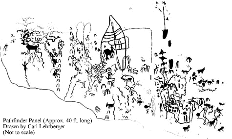

Pathfinder is a 40 X 12 foot slab of sandstone rock with a flat, East facing surface covered with petroglyphs. A large boulder to the East leans onto the southern half of the Pathfinder, creating a cave. The extended northern part of the Pathfinder panel is exposed to the direct sunlight at sunrise with a distinct shadow cast by the adjoining boulder.


The Pathfinder site has a vast array of images. The most noticeable is the howling dog petroglyph which has an interesting stream of symbolic figures emanating from its mouth. 
To the South of Dog, more petroglyphs are distinguishable. Most notable is a large wing-like or sail-like image with horizontal lines. This is the equinox Target for the shadow created by the adjacent boulder to the East. The Target and the Dog glyphs are the largest and most prominent petroglyphs on Pathfinder. Below the Target are a series of petroglyphs including a human figure, abstract and representational animal glyphs.
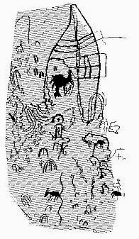
Equinox Shadow representation
At sunrise on the day of the equinox, the Dog glyph is illuminated by the first light. The shadow created by the adjacent boulder emerges at dawn and begins to engulf the Target. As the sun rises, the shadow edge fits the northern outline of the Target. Because of the cave-like conditions for much of the rock face, it wasn’t possible to observe or photograph Pathfinder in its entirety. Only by drawing details of the photos taken was the panel able to be re-created. At least two different styles of petroglyphs can be seen: earlier abstract characters and figures and later representational petroglyphs. There are also unique sequences of parallel lines, but they were too worn to be distinguishable.
A Native American archaeo-astronomical petroglyph was also found at Pathfinder. It is believed to be of Changing Woman, a person found in many Native Tribal Stories. Changing Woman is crossed with a dagger of light on the Equinoxes.

Many scientists feel that there should be physical evidence or artifacts to support the claim that the grooves are Ogham writing. There probably were artifacts at one time but repeated flash flooding through the centuries has washed away or covered up any artifacts that may have been there. The fact that most of the petroglyph panels are 10ft or more above the bottom level of the canyons and arroyos supports this theory of flash flooding stripping away the soils found in the bottom of the canyons.

Tuesday, April 14, 2015

Old World Graffiti Along the Arkansas River

***This is a presentation which I recently gave. I have not yet visited these sites.***


My interest in petroglyphs began when I was a child growing up in the San Luis Valley where petroglyphs seemed to be everywhere. As I aged and began to delve into art, my interest in petroglyphs continued. I found it interesting to see how ancient peoples viewed their world and described it in the artwork they left behind.


The majority of the petroglyphs found in the southeast corner of Colorado are in and around the Comanche National Grasslands and they are quite unique. They're believed to be Pre-Columbian and of European Origin. SE Colorado is an area of short-grass prairie with canyons and hoo doos carved out by the waterways which bring the essence of life to the area. The Arkansas River flows through here on its way to the Mississippi. But the Arkansas isn't alone - the Purgatoire River & Apishapa River along with numerous smaller waterways feed the Arkansas. This area was frequented by various people through the eons. Some might have been nomads, simply following the herds. Others could have been explorers, looking for ore to mine or new land to populate.


The mesa tops provided a place to scan the plains for buffalo or antelope while the canyons offered shelter from the unrelenting sun or sudden storms. The river bottoms provided fertile land for agriculture. It is amongst these caves and other niches that the people who visited this area left their mark. Graffiti of sorts. At least that is what it would be called today. But this Graffiti wasn't made with cans of paint but rather by scraping and carving the rock, leaving behind Rock Art. These people were determined to record events, thoughts, ideas for posterity. 


pecked petroglyph
carved petroglyph
Rock art can be petroglyphs or pictographs. Petroglyphs are symbols which have been carved into stone - they can be pecked resulting in round indentations as well as scraped or carved into the rock resulting in a more defined glyph. Carved glyphs last longer. When creating a glyph, the patina or rock varnish, is scraped off leaving the bare rock face exposed. Depending on where the glyph is located - area of the country, location on the rock - a glyph may remain readable for centuries. Petroglyphs should not be confused with pictographs - pictographs are painted on.

SE Colorado map
C - Crack cave   S - Sun Temple   P - Pathfinder
There is an abundance of rock art here but there are three specific sites of interest. Crack Cave, Sun Temple and the Pathfinder Site. These sites have the typical rock art attributed to the Native Peoples of Colorado but they also have some unusual markings which have been determined to be an ancient form of writing found in the British Isles and Iberia - all locations where the ancient Celts lived. This writing is called Ogham. 

Ogham writing on rock in Ireland
Ogham is the oldest form of writing in Ireland and Scotland. It can still be seen inscribed on hundreds of large and small stones, on the walls of some caves, but also on bone, ivory, bronze and silver objects. The Ogham script was especially well adapted for use on sticks. And sticks were always in ready supply and easier to carve on than rocks. Ogham writing has been discovered at Stonehenge dating to 2200BCE.
The true origin of Ogham is unknown. A 7th century Irish text states that the origins of Ogham should be sought in the Near East. It may have originated in Libya.  It is believed that the Phoenicians came from the region which encompasses Libya and they settled the areas of Spain where the early Celts lived. The Phoenician later expanded their journeys to include Ireland and later Scotland and England. As these skilled seamen settled in new areas, they brought their customs, knowledge and beliefs with them. The Ogham found in Europe is usually written vertically while the Ogham carvings here are written horizontally. This may be because it was easier to find long uninterrupted horizontal surfaces on the rock walls. Irish monks, centuries ago, translated Ogham into Gaelic which has enabled Ogham to be translated into English.

Stonehenge - the most well known Archaeo-astronomical site

All three of the sites I’m going to tell you about are archaeo-astronomical sites. Archaeo-astronomy is the study of how sky watchers of the past understood the phenomena in the sky, how they used these phenomena and what role the sky played in their cultures. Often the people relied on sunlight and shadow plays striking and passing across targets and designs which were aligned with Equinox, Solstice and Cross Quarter sunrises and sunsets. The celestial cycles of the moon, Venus and Mars captivated their attention, as well. Knowing seasonal durations and transitions was vital to their success in hunting migratory prey and planting and harvesting crops. Archaeoastronomy draws on several scientific disciplines, primarily astronomy, archaeology, anthropology, psychology and epigraphy (the decoding of ancient inscriptions).

***Part 2 tomorrow!***

Friday, March 27, 2015

Roadtrip ~ Grand Canyon of the Arkansas


An impromptu roadtrip took us to uncharted territory. It was a beautiful Sunday and we wanted to get out and enjoy it. So off we headed to see the Grand Canyon of the Arkansas.
We headed south and were soon in the town of Penrose where we stopped to see the World's Largest Rocking Chair!

World's Largest Rocking Chair - built in 1990 from hand-hewn Douglas Fir logs,
weighs 9100lbs. 21 ft tall & 14 ft wide
This chair is located next to a really neat old building that may have a unique future in store for it.


From there we continued on to the quaint little burb of Canon City. We decided to stop for lunch and when we found a place named after hubby, we knew we had to stop! Boy, we were not disappointed! We had a lunch that reminded us of a Sunday dinner at Grandma's house!


Onward we went. We slowly climbed Fremont Peak. Driving through the area which had been ravaged by wildfire less than two years ago. Stark was the landscape. But signs of life were evident. Cattle grazed on grass and the tall stalks of mullein could be seen. While mullein is on the invasive species list, it serves a very valuable purpose in these burned areas by holding down soil and preventing severe erosion.


Mullein stalks silhouetted against the sky
The 2013 fire, which burned for four days, destroyed nearly 90% of the park. Only the bridge was left standing with only minimal damage to the wooden floor planks.

Smoldering building - image source
bridge fire damage - image source
When we arrived at the summit, a vast vista opened before us. The vastness of the canyon which lay before us was amazing. And to think it was carved by a river through granite! This place was aptly named - the Royal Gorge!


The Royal Gorge or Grand Canyon of the Arkansas is only about 50 feet across at the bottom and several hundred feet across at the top. It's roughly 1,250 ft deep and the canyon is 10 miles long.


The first documented exploration of the region was by Zebulon Pike in 1806. A railway through the gorge was built in the late 1870s. 


railroad tracks at bottom of  Royal Gorge
The Royal Gorge is owned by the local town of Canon City. In 1929, the town of Canon City had the bridge across the gorge built. The bridge is 955 feet above the river and held the title of the highest bridge in the world from 1929 to 2001. It is still America's highest suspension bridge.


To read more about the Royal Gorge, Click Here!